The solstice weekend has now become something of a biking tradition; it
is usually the perfect time to head away on the bikes – the height of
summer. However, so far this year I have yet to witness a summer and
unlike 2014, we would be lucky to see the solstice sun. There would be
three of us on this run, with Kivi and I leaving Belfast on Friday and
Dee joining the merry gang on Saturday, “somewhere near Enniskillen” (I
liked the vagueness!). Leaving relatively late on Friday means that we
inevitably stay at Meelmore Lodge, nestled at the foot of Slieve
Meelmore in the Mourne Mountains. The journey there was in the humidity
of a late summer evening, although on the outskirts of Newcastle I
noticed that the mountain tops were hidden beneath low cloud that
appeared to be tumbling down the sides towards the town, like a whitish
grey wave. The campsite makes an ideal base, although the stony ground
at the top field makes getting the tent pegs into the ground something
of a challenge, and I had pitched my tent at a near 90 degree angle to
the slope, almost guaranteeing an uncomfortable night’s sleep – you’d
have thought by now I’d have learnt! The next morning began the low
clouds were still present, only now mists also rolled ominously down the
brown and beige slopes, so it seemed appropriate to have the linings in
my Dianese jacket – this would be a decision I would later regret!
 |
| The Explorer at Meelmore |
 | |
| (Top) Navan Fort (Below) Interior of Armagh Cathedral |
Armagh has recently become something of a revelation to me, it is a genuinely beautiful town, steeped in history. It was outside Armagh that I directed an archaeological excavation at Emain Macha (Navan Fort) - according to Irish mythology, it was one of the great royal sites of pre-Christian Gaelic Ireland and the capital of the Ulaidh. Excavation showed that beneath the mound had been a huge structure of concentric rings of posts which had been filled with a cairn of boulders. There were also traces of houses, rebuilt on the same spot several times. However, the town of Armagh is also beautiful; the name comes from the Irish Ard Mhacha, meaning ‘Macha's height’ (after the goddess Macha) and this name was later anglicised as Ardmagh eventually becoming Armagh.
Armagh rose to prominence in the 5th Century during the spread of Christianity through Ireland, there was a monastery here raided in the mid-9th Century but most famously this monastery produced the ‘Book of Armagh’ now housed in Trinity College. Brian Bóruma (Brian Boru – a High King of Ireland) is thought to be buried in the grounds of St. Patrick’s (Church of Ireland) Cathedral. Our destination, though, was St. Patrick’s (Roman Catholic) Cathedral. Built in the 1840’s there is, to my eye, something of a Gothic Revival style to the building, although even in the blazing sunshine the twin spires were imposing. My thoughts soon left the architecture and turned to how quickly I could remove the thermal lining in both my jacket and trousers, so I found a spot at the rear of the church and got everything off as quickly as I could (I will not go into detail as to how good the air felt when my trousers came off!). Now more comfortable, I was able to marvel at the church’s decorative and stunning interior, the tiled floors and the high vaulted ceilings imitating the rib-vaultng of splendid Medieval cathedrals. We were there at the same time as a wedding was due to commence, so our visit was, alas, fleeting, but still awe-inspiring. The tiered grounds were exquisitely manicured and gave superb views to St. Patricks (Church of Ireland) Cathedral and the town of Armagh itself - an ideal location then to sit for several minutes basking in the sunshine and the inner peace that riding the bike seems to afford me.
Our next stop was Enniskillen where we were due to meet Dee; I was glad to leave the traffic behind in Armagh, travelling west on the A5 towards Aughnacloy and Ballygawley. These small towns and villages tend to 'meld' together, the long road seemingly punctuated by these similar little urban clusters. We had been through Aughnacloy on our last bike trip in May, and I remember remarking about how the town seems to have lost its lustre, it seemed like it was 'dying' somehow, and I'm afraid to say this drive-through only seemed to reinforce that earlier impression. Outside Ballygawley, we turned south-east on the A4, passing Colebrooke Estate and Park: the estate is the seat of Viscount and Viscountess Brookeborough, the centrepiece of the 1000 acre estate being the 19th Century neo-Classical country house.
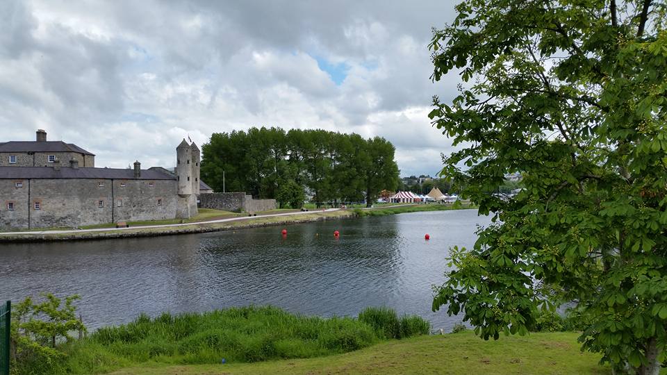 |
| Enniskillen Castle |
We met Dee on the banks of the Erne River opposite Enniskillen Castle. The castle has a long past, built in the early 15th century by the Maguires (Mag Uidhir) in a strategic position on the River Erne. Their rule lasted for over 300 years from the end of the thirteenth century to the beginning of the seventeenth century. In the early fifteenth century, one of the junior branch of the Maguires, Hugh 'the Hospitable' Maguire, established a second stronghold at Enniskillen. Hugh Maguire died in 1428 therefore the castle must have been built before then, sometime during the 1420s. The Annals of Ulster record the castle at Enniskillen (or Inis-Ceithlenn) in 1439: “Mag Uidhir was taken prisoner this year (namely, about the feast of St. Patrick) by Domnall Mag Uidhir the Freckled, in the castle of Mag Uidhir himself and Philip was liberated the same day by Domnall. Afterwards, when Henry Ua Neill heard that Mag Uidhir was in custody, he mustered many forces and went to Port-abla-Faelain against Philip and Domnall, with whom Mag Uidhir was in custody. Mag Uidhir was liberated that day and hostages were given for him….and the castle of Inis-Ceithlenn (namely, Inis-Sgeillen) was given to Domnall Mag Uidhir the Freckled.” (Balé et al, 2010, U1439).
The original structure was originally built as a small square tower house surrounded by a curtain wall which frequently came under attack. Following the castle’s destruction in 1508 it was rebuilt, this time much larger and in a rectangular shape. Between 1508 and 1602 the castle was besieged, taken and returned to the Maguire’s no less than six times before it was totally destroyed. Captain William Cole was responsible for the rebuilding of the castle in 1607, during the 18th century the castle was remodelled again to become a military barracks.
 |
| The water-powered saw mill at Florence Court |
Now a party of three, we were travelling almost due west on the A4 for Belcoo, I was leading when at a set of traffic lights Kivi pulled up alongside and suggested revisiting the superb National Trust estate of Florence Court. We had visited the estate last year during our 'National Trust tour' and had been impressed with the house and grounds. This time, though, we decided to amble in the grounds rather than re-take the house tour. We discovered the water powered saw mill, something we had missed in 2014, it was fascinating to see the large, and presumably original, water wheel still powering the gears and ban-saw. . Alas we also saw the remains (now unfortunately a mere footprint) of the listed thatched summer house that was burnt down by local 'hoods' in August of 2014.
We were soon at Belcoo which is sited at the meeting point between Lough Macnean Lower and Lough Macnean Upper, the road then seamlessly becomes the N16 towards Sligo and the west. Outside Glenfarne, the road is flanked to the north by the breathtaking Dough / Thur Mountains which are a Natural Heritage Area and further west by the Crockauns / Keelogyboy Bogs Natural Heritage Areas, the Dartry Mountains also lie north towards the coast. We had pulled over on the roadside and I simply looked at awe at the Glencar Lough valley and mountains; they were like a painting, rather than a real landscape before me. Our eventual destination was Strandhill, a camping area and surfing town in which we have begun to stay more and more. We feasted that evening on the burgers in The Draft House (along with a few pints of Guinness!) before I flopped into my tent for a sound and deep sleep (quite in contrast to the previous night in Meelmore).
 |
| On board still shot |
Another tradition has become breakfast in Shells Cafe that overlooks the Strandhill beach and shore, this was Dee's first taste of Shells' breakfasts and I don't think he was disappointed! We wanted to travel north towards Drumcliff (the resting place of W.B Yeats) before some brief road time west to Lissadell House. The house has a deep history, probably most famous as the home of Constance Markievicz (née Gore-Booth), better known as the Countess Markievicz - a national hero, symbol, Sinn Féin and Fianna Fáil politician, revolutionary, suffragette and socialist. However, the tour (and I use the term very loosely) cost 12 Euros and all that is open to the public are 4 or 5 rooms (several of which are the basement servants rooms): the house was bought by barristers from Dublin and since their purchase, there has been a rather fraught relationship with the local Council and the wider public, including court cases etc. I think there are over seventy rooms in the house, seventy-two if my memory is correct, so to have just over 6% of the house open and to charge so heavily for the privilege is a little cheeky in my opinion - it works out at just over two Euros per room to view what is allowed! We weren't deflated though, I think each of us was riding high on the camaraderie that biking offers, but more than that we were travelling through some of the most stunning, bucolic, and seductive countryside there is and the bike made us at one with our environment, but the very act of riding the bikes had also given spiritual peace, to me at least.
Outside Drumcliff, we turned east off the N16 following the signs for Manorhamilton, these were the 'back roads' and I can honestly say, they were some of the most beautiful I have ever ridden. The road sits in a valley of sorts, with almost sheer and dynamic hills and mountains almost right beside, they loomed over us. Eventually, the area opens out to the right to Glencar Lough, our destination was the spectacular Glencar Waterfall. Glencar comes from the Irish Ghleann an Chairthe meaning 'lake/glen of the pillar/standing stone'.
 |
| The lads shooting the breeze by Glencar Lough / Lake |
Glencar Valley lies between the Dartry Mountains to the north and the mountain range including Cope's Mountain to the south. Historically Glencar Valley was known as Glenn-Dallain and was part of the Kingdom of Bréifne. The Kingdom was the territory for an early tribal group known as the Uí Briúin Bréifne. The Bréifne territory included the counties of Leitrim and Cavan, along with parts of County Sligo. At its height in the 12th century, when Tigernán Ua Ruairc was king of Bréifne, it extended from Kells to Drumcliff. The lough contains two crannogs (habited islands) that are mentioned in the Annals of the Four Masters, specifically the eastern crannog. In 1029 there was a reference to: "Hugh O’Ruairc, Lord of Dartry; and the Lord of Carbury; and Aengus O’Hennessy, airinech of Drumcliff; and three core persons along with them, were burned in Innis-na-lainne in Carbury Mor. Innis-na-lainne (i.e., the Sword Island) is certainly the eastern crannoge in that expansion of Glencar River, which is now called Glencar Lake or Lough-na-Glena.” (O’Rorke, 2014). It seems likely that another reference refers to the same event of the burning of noblemen on the crannog: "The eastern Cranoge on the lake of Glen-Dallain was taken by the sons of Donal, son of Donogh O’Rourke, from Donogh. Sometime after the sons of Donogh O’Rourke, namely, Donal and Ferganainm, made an attack on the Cranoge, and privately set fire to the fortress; that act was perceived and detected, and they were pursued on the lake, the son of Donogh was slain, and drowned by them, and Donal having been taken prisoner, was hanged.” (O’Clery, 2003, 418).
 |
| Glencar Waterfall |
Beside the lough is a walking route seemingly into the forest that is the way to Glencar Waterfall. As we made the approach the sounds of the waterfall is audible before it is visible, and initially it is something of a 'roar'. But as I rounded the corner, the scene that greeted me was so beautiful, it was almost unreal. The falls are approximately 50ft (just over 15metres) in height and the sheer volume and diversity of the plant life around it is like a picture from a rainforest. It seemed impossible, surely, that we were still in Ireland?!
Whilst at the viewing platform, Kivi noticed a Grey Wagtail fluttering near the water surface, presumably feeding 'on the wing'. By following its trajectory we were able to trace where its nest was located. I stood struggling to take in my surroundings, and the talk, inevitably, turned to the next biking trip! It was at this stage, I think, that we all realised the riding now was homeward. We joked as we ate ice-creams in the car park that we could just hop on a ferry and continue the journey (who knows...maybe to Scotland? Europe was also talked about!). But the reality is that jobs have to be worked to pay for the bikes, the equipment and the short trips away. These weekends are like short dreams, a taste of pleasure that is undiluted and pure - the journey home was emotionally now like the weather, grey and overcast.
The journey back towards Belfast was primarily via the main roads, although we did stop in Enniskillen for one last 'pig-out'. It had started to rain periodically and a tirdness had come over all three of us. I don't like motorways; to me they are uninteresting and soulless, grey swathes of dreariness that are there simply to get from A to B as fast as possible. Even larger 'A' roads are preferable, but you see nothing of a country on a motorway, just the dust and pollution stained trees that sit sadly by the hard shoulder.
We have talked about at least one of these trips a month over the summer months, I sincerely hope that they come to pass...I need them, more importantly my soul and spirit needs them.
No comments:
Post a Comment