Friday 23 November 2018

Sí an Bhrú (Newgrange)

A visit this week to the World Heritage Site has got my proverbial juices flowing. It has aroused not-so-dormant curiosities in all things archaeological! Newgrange is known as Sí an Bhrú with the latter word sometimes spelt brugh or brú, (the same word as Brú in Brú na Bóinne). This word is sometimes translated as ‘palace’ or ‘mansion’ and therefore Newrange is often referred to as the ‘palace of the Boyne’. However, the old Irish word for womb is Brú and so Brú na Bóinne may actually be more correctly translated as Womb of the Bóinne/Boyne, rather than palace or the mansion of the Boyne.

The term (sometimes síd or sídh) is usually associated with mounds and fairy mounds. Probably the oldest meaning of relates to “(the) Otherworld”: that is the subterranean world of the Tuatha Dé Danann and Aos Sí in the literary traditions of Ireland, Scotland and the Isle of Man. The second – and later – definition of is “Otherworld Residence, Territory” (pl. Síthe). The majority of Síthe were equated with the ancient burial mounds and graves that dotted the landscapes of Ireland, though the term was sometimes applied to other areas associated with the supernatural like notable hilltops, caves, springs, lakes and certain wilderness locations (An Sionnach Fionn, 2009).
The entrance, entrance stone and passage at Newgrange
If the alternative translation is applicable, it perhaps gives even more significance to the sites in terms of their ritual function, that is to say, if these monuments are/were referred to or thought of as ‘wombs’. One is perhaps hesitant to use the term because of ‘new-age’ connotations, but ‘mother earth’ springs to mind; returning the ancestors to an other-worldly and comforting realm. It would also further the significance of the solstice as an experience given this great ‘womb’ along with Dowth is aligned with the winter event (an alignment of Knowth is conjectural, but hypothesised to align with the Equinox – akin to the Loughcrew complex). In days that now seem so long ago I studied the Boyne Valley and its archaeological significance (memories of Waddell’s ‘The Prehistoric Archaeology of Ireland’), learning facts such as; the Beaker People's influence, it predated Stonehenge, it predated the Great Pyramids and so on. But facts and figures offer little substitute for experiencing these places, although one fact I will hold onto is that there is a smaller mound that predates Newgrange on top of which it was built.

With the Bóinne cultural landscape a World Heritage Site since 1993, a wider appreciation of heritage sites in the public psyche and the inexorable rise in cultural tourism, it is no surprise that such sites attract visitors. Infrastructure associated with guiding people to these places is now ever-visible, as are attempts (understandably) for businesses to somehow associate themselves with it and take advantage of the passing trade. Newgrange (alongside Knowth and other similar monuments - I wrote about a trip to Knowth in 'Biking Through the Brú na Bóinne') never fails to impress once standing in front of them. It’s easy to see them in splendid isolation, but of course they were and are surrounded by other associated structures and sites, indeed there are a collection of standing stones to the front of Newgrange as well as numerous other smaller satellite passage tombs, a series of henge sites, cursous, ancillaries and a later Bronze Age woodhenge. There was, just this summer, the spectacular discovery of other monuments and another sizable henge. It begs the question 'just what were they doing here?'.

For me it is tempting, and would almost be easier, to write an archaeological critique and analysis of the site, and make it quite dry for the reader; something I have been guilty of in the past, but something I just can't help - the old academic in me will never quite die! Instead I thought I would focus on visiting the monument, peppering it with some facts, and concentrate on how it made me feel.

The incised decoration and stone bowl in the western chamber
The approach to the site is dominated by the white quartz façade that is, I'm reliably informed, reconstructed based on archaeological evidence from Prof. O'Kelly's excavations in the 1960's. I remember being told when excavating Ballynahatty that the Giant's Ring henge in Belfast would originally have gleamed with white quartz as well, excavations of cremation burials often also had quartz stones associated with them, sometimes placed at the compass points next to the urn. These sites would have, therefore, literally been beacons within the landscape. However, the façade reconstruction has and did cause some consternation and debate amongst archaeologists. The standing stones to the front almost act as guides to funnel one towards the entrance that is, in itself, imposing to say the least. You are greeted by the great decorated curb stone and two passages (the upper is the light box for the winter solstice sun atop which sits a great chevron decorated lintel).

To enter, a stoop is necessary, minding the protruding capstone that looks like it could do some damage - and nearly did to my head on exit! The passage is lit, but even so the gloom seems to enclose you both literally and metaphorically; maybe it is like entering a womb or a warm embrace of the earth? In places the orthastat[s] lean in and this means if claustrophobic, this would be somewhat unsettling. Then the great corbelled chamber opens out and there is a sense of space; the height of the ceiling is as equally surprising as the complexity of the construction. Immediately the sheer amount of different decorations on stones becomes apparent, they are everywhere - spirals, circles, chevrons, lozenges and triangles. The designs on many stones continue on surfaces now hidden and excavations revealed that many stones are carved on their undersides and on the sides turned inwards to the cairns. Therefore it may not always have been important for the whole design to be visible which would suggest that the design and perhaps the decorated stone itself was significant, rather than the viewer or their interpretation.

The famous triskele at the back (north) chamber
I had to keep reminding myself that the place was over 5,000 years old! The art intrigues me; what was it's purpose and what did it mean? There has been, of course, much conjecture with the spirals and circles postulated to represent the sun and movement of the sun's course across the calender year. The chevrons have been interpreted as darkness and there is no doubt in my mind, remembering the solstice alignment, that light and dark and the celestial movements were significant. It is hard to argue against the famous ‘r’s in terms of purpose; ritual or religious significance. The purpose behind these monuments is theoretical, some have argued either as a place of worship for a ‘cult of the dead’ or ancestor worship (anyone familiar with Time Team will know of Francis Pryor’s fascination with ancestor worship), or for an astronomically-based faith. Prof. O'Kelly believed, rightly in my view, that the monument had to be seen in relation to the nearby Knowth, Dowth and the wider landscape, and that the building of Newgrange "…cannot be regarded as other than the expression of some kind of powerful force or motivation, brought to the extremes of aggrandizement in these three monuments, the cathedrals of the megalithic religion." (O’Kelly, 1982). O'Kelly argued that Newgrange, alongside the hundreds of other passage tombs built in Ireland during the Neolithic, showed evidence for a religion that venerated the dead as one of its core principles (Ibid).

Townley Hall - Little Grange - Summer Solstice (Ken Williams)

At one point, the interior lights were switched off and standing in the darkness fundamentally changed the space and its impact. After this a 'fake' winter solstice effect is created to show what the chamber is like when lit by the shaft of sunlight that hits the back (north chamber wall) and illuminates the famous triskele on one of the orthastat uprights. It was only recently that I discovered a nearby small passage tomb called Townley Hall, not often visited, but it also has an alignment with the summer solstice as imaged by Ken Williams of Shadows and Stone. In his image you can clearly see the alignment; excavated by Prof. Eoghan prior to his long term excavation at Knowth, the sockets for the missing passage and chamber stones were located and can be seen by the concrete placement  slabs.

The point is that within this cultural landscape there are almost too many monuments, many very large and significant, to count, all of which required thought, engineering and exceptional will to complete; many are aligned to celestial events (including winter and summer solstices [proven] and equinox events [proposed] alongside others that might yet be discovered). Therefore, the laws of probability would conclude that these monuments acted together throughout the year. They were special then, they remain special now.

Friday 31 August 2018

Into The Lakelands

Into The Lakelands

Thursday 23 August 2018

Leitrim's Payback

As I write this, Leitrim’s payback has been hard felt; for the first time in my biking ‘career’ I have come back from a biking weekend full of aches – especially in my legs and back – as well as a rather painful mouth ulcer….I must have been more tired and rundown than I thought! The alternative narrative is that the part of the ride on the Saturday in the most torrential rain I have ever ridden in has had an impact on my ever-ageing body. The weekend had been planned after the last July trip to roads as yet unexplored which had been something of a revelation; we have visited the main hotspots extensively previously, but we thirst to see places that are new to us. This ethos inevitably leads to more remote locations and more challenging roads – this weekend was perhaps the zenith of this approach.

We had booked a cottage near Killashandra, a small town in Co. Cavan; Cavan is one of those counties that people think has not a lot within it, a poor neighbour to the likes of Meath and Sligo, but it is ancient and charming because it isn't visited as much, it therefore has the feeling of being undiscovered and relatively untouched. Killashandra is derived from the Irish Cill na Seanrátha meaning ‘Church of the Old Rath’ and is in the middle of the Cavan lakelands – an area popular with those that enjoy fishing. In decreasing light the initial journey on the Friday night involved some motorway work to get out of Belfast’s urban sprawl; the days of daylight after 9pm are now long gone. After forming our group outside Keady, the journey was west south-west on the N2 to Clontibret then to Monaghan and the N54 to the ‘twisties’ outside Castlesaunderson and the R201 to Milltown.

Into the Lakes
To the immediate north of Town Lough, we turned off the R201 to a narrow side road, the glow of the sat-nav was being blindly followed and I am happy to admit a complete reliance on it, the road soon forms a causeway over the Lough before turning west on the R199. This latter part of the journey was interesting to say the least; the road is narrow, overhung by large trees that seem to make the night even darker and with a grass centre dividing the two tarmac 'strips' that means that, in essence, the bikes can only use a quarter of the road width. In night and with rain falling this made it exceptionally challenging – at one point I must have hit the grass and the back end slid out to my right side, there was a momentary thought - "I'm going down" before instinctively I put on opposite lock and applied some power, allowing the traction control to take over. Thankfully the bike corrected itself and I was again on the narrow strip of tarmac. A close call!
Map of the Saturday route to Parke's and Ballindoon
The cottage, only 2km from the Leitrim border, was a welcome sight; seemingly on its own, it was actually one of a number of gate lodges for the nearby large manorial site and was perfect for the occasion. We soon lit the large wood burning stove, a pleasing hiss as the last of the moisture from the logs was driven off before catching light, it is amazing how such a thing adds to the sense of homeliness. Within minutes, the craic was mighty and it seemed like it hadn't been so long since we had all been together. There was a variety of spirits brought and the revelation of the night were the delectable 'Dark & Stormy' cocktails - a mixture using ginger beer, lime, dark rum (in this case Gosling's Black Seal Rum) and a few dashes of bitters; a perfect sipping drink if ever there was one! My best laid plans for some quality White Russians was immediately thwarted when I gazed, disappointed, into my creation to see that it resembled something that had left a body in a hurry, rather than something that should go into the body in a hurry! The plan for the following day was firmly set; Parke's Castle on the Leitrim / Sligo border on the northern shore of Lough Gill -  a decent journey west. We awoke early on Saturday morning, determined to get a full day on the bikes, initial concerns, though, were all about empty stomachs and where we could get a good breakfast. We were again soon on the R199 north of Garadice Lough in search of this!

The Wetlands to Parke's
The first town we came across was Ballinamore, proudly displaying banners for the Ballinamore Family Festival. We, though, simply wanted a full Irish breakfast and duly stopped at a hotel in the town centre. We entered to find a group sinking pints and the atmosphere wasn't exactly conducive to a relaxed breakfast so, with a degree of haste, we decided somewhere else would be a better bet. Fortunately the appropriately named 'The Corner' situated on the corner of Main Street provided one of the most delicious full breakfasts I've had in quite a while. The little café overlooks the Yellow River (modernly referred to as the Ballinamore-Ballyconnell Canal). It is from this river and its importance that the town gets its name, Anglicized from Béal Átha Móir ('mouth of the big ford').

Stopping for a break near Parke's Castle
We travelled west on the R208 that is seemingly flanked my numerous loughs and lakes; these bodies of water are everywhere - St. John's Lough, Lough Nacarriga, Corrachoosaun Lough before passing much larger bodies of water like Lough Scur which had Mesolithic flint flakes found around its banks (Driscoll, 2006, 229). The countryside is of flowing drumlins and there was a serenity that came over me when riding in this sort of landscape, the road[s] seem to flow with the land around rather than 'fighting' it. Perhaps it's the joy of having these large areas of fresh water - the road builders had little choice but to work in sympathy with the terrain. Around the Roscommon / Leitrim border we turned northwards flanking the western shore of Lough Allen on what is now the R280 - I remember parts of this road from a previous trip to Sligo in July 2017, the drumlins seem to give way to areas that are much more densely wooded and feel more 'wild' as a result. Following signs from Dromahair we turned due west onto the R289 before entering the village proper. The centre felt quaint and compact and the village is ancient in origin. It is named from the Irish Droim dhá Ethair ('ridge of two demons') which is so named after a ridge of high ground above the Bonnet River. This ridge was the site for the foundation of a 5th Century Christian site of Drumlease. The village was also the seat of the O'Rourkes and the capital of a medieval Briefne. Only now did I realise that immediately outside the village lies the remains of Creevelea Friary and within it [the village] is a 13th Century hall-castle and later fortified house associated with the O'Rourkes. My research must be slipping! 
Main entrance (east façade) of Parke's Castle
The original gatehouse (white block) with later manor house attached

The road (now the R286) hugs the western shore of Lough Gill, with plenty of twists and turns; it was a joy to again be 'throwing' a bike left, right, left then right again, applying a little counter-steer to tip the bike into the direction of the corner. Then, gradually revealing itself, was the outline of Parke's Castle. When someone mentions a castle to me, my mind initially thinks of Anglo-Norman fortresses, the ones I studied many years ago: Dundrum, Trim, Ballintober, King John's (Limerick and Carlingford) etc. Parke's seems more delicate, for want of a better word. It is later and with a heavier slant towards domestication rather than the pre-dating military fortresses. But it seems more inviting perched on the lough shore. The site is undergoing some internal works (thatching the old forge), and was free in as a result. But it was pleasingly quiet with only a few small groups inside. From a visitor experience point of view, for me, this is key as a cluttered busy site is one I seem to naturally shy away from.

We took the excellent tour to learn that Parke's is the later name for the site, previously known as Newtown or O'Rourke's Castle. The courtyard excavations revealed the foundations of an earlier 16th century tower house - the original O'Rourke stronghold - with a pentagonal bawn wall surrounding it. Conveniently differentiated by its colour (white), the original gatehouse was subsumed by the  later additional manor house. It was in this original tower house the O'Rourke entertained the shipwrecked Spanish Armada Officer Francisco de Cuellar, an act that no doubt helped his ultimately execution for treason in 1591. It was after the O'Rourke era, in the early 1600's, that the castle was gifted to Sir Roger Parke, an English planter and captain, and it is from this family line that the castle is now known/named. They domesticated the arrangements, using the stone from the tower house to construct the manor house that became their main residence. We walked the castle walls, and your eye is immediately trying to take in the scenery, the views over the lough and neighbouring countryside genuinely breathtaking. It was here that the OPW Guide informed us of the rumours of an impending downpour later that evening....how right she would be! On my list of sites in the area one stood out; Ballindoon Friary. We had time to visit this and then get something to eat in Carrick-on-Shannon before heading back to the accommodation, so with this plan in mind we headed due south towards the friary - it was, though, on these roads constantly flitting between Leitrim and Sligo that we had to pull over to give our bodies a break.

Who Needs Waterproofs?
The journey to Ballindoon is on the R284, at times nothing more than a track between seemingly baron fields or solemn trees, the surface was rutted and challenging; in many areas I had to stand on the pegs not only for my own sanity, but to give the suspension a break! The distance from Parke's to Ballindoon is only approximately 30km, but it definitely felt much longer. The road is within inches of Lough Bo and that particular area feels feral, like we were genuinely stepping back . At Killadoon Crossroads, literally a meeting of roads and tracks, we simply had to stop; my arms were shaken off me and I have no doubt that everyone else's were too, but were only 2km away from the friary and we continued. Then, seemingly rising out of the landscape, was the remains of Ballindoon Friary. My immediate impressions were that the land seems to be slowly reclaiming and enveloping the site; it has long been abandoned (the friary was dissolved in around 1585), but this reclamation process looks almost like an act of predation by the trees and ivy.

Ballindoon (Baile an Dúin) Friary
The site is a Dominican priory within an earlier ecclesiastical enclosure, built in one architectural style - 'Middle English Gothic'. The church (now comprising the nave, chancel, tower and transept) was founded in 1507. Although it is easy to view it in splendid isolation perched 6m above the shores of Lough Arrow, it has to be looked at within the context of the larger holy site (that also includes a font, ritual holy well, the ecclesiastical enclosure) as well as the nearby Ballindoon House which itself contains a large early ringfort/rath. As we soon observed by the freshly dug graves, the site is still used today and for that reason still exudes a reverence, despite its decay. It was in one of the dark interior rooms that the lads, presumably through a sudden change in light conditions, noticed that one of the earlier headstone carvings aesthetically changed to a relief formation. To be there at that specific time, change of light etc was a million to one shot! Chance or design....now there's the great debate! By this stage the breakfast sustenance had worn off and hunger was setting in, an Indian in Carrick-on-Shannon was widely agreed on, and we duly set off south towards the town dominated by that great river. It was with more than a little relief that we turned off the R1013 just north of Lough Key onto the N4....smooth roads again....bliss! We were able to ride past the backed up traffic just west of the town to Shamrat (Spice) Indian Restaurant. By the time we had finished the clouds had gathered and they were dark and heavy.

The rain commenced in anger, and it was a deluge. We had no choice but to ride through it and as we set off east it became apparent very quickly that even with the best of gear, we were not going to stay dry. Water was lying in deep pools on the road such was the sheer volume of rain and as it splashed up onto my trousers and boots I realised that I was struggling to see. Even a slight lift of the visor did little to help with vision. I was somewhat surprised (and relieved) by how well the big Triumph gripped and handled. As soon as I felt the water running down my chest, though, I could only laugh and accept just how drenched I would be by the journeys end. More than one time I saw frogs hopping across the roads, this is no exaggeration, it was that wet! It was with more than a little relief that we all arrived safely back at the cottage; the floors soon like the shallow end of a swimming pool as the water dripped off all the gear. The fire was again lit, a genuine necessity, and I will attempt to claim that the rum was purely for warmth!

There is something that happens on trips away on the bike, a head space and zen-like state that seems to be inevitable. But getting diaries that sync is getting ever harder. There remains so much to see on this isle, the question is always; 'where to next?'.

Friday 15 June 2018

The Tropical Midlands

An Irish summer, it seems to me, can be hotter than traditional holidays to 'suntraps' abroad. I don't know why but the sun seems stronger somehow, more ferocious and I have a tendency to more readily burn in its intensity. The last few weeks have been thus and we were due to take a biking weekend away - the first in a year - at the tail end of this tropical bake. Cavan is an under-visited county, seemingly the poor neighbour to the likes of Meath and Sligo, but this also has the advantage of lowering prices for accommodation. When I researched what there was to see and do there were a surprising amount of little sites in close proximity such as Drumlane, Aughrim wedge tomb and even Abbeylara, but for larger attractions (Louchcrew, Parke's Castle, Strokestown et al) there is a bit of a drive involved. That was fine though, as with so little saddle time between us over the last 12 months, a drive was what was desired.

With it fast approaching the Summer Solstice the nights are short, with streaks of pale daylight still visible around midnight; it seems hard to believe that in little over a week's time the days will start getting shorter! The times seems easy with so much light, it adds an 'airiness' to one's psyche. Little wonder, then, that in ancient times it was the Winter Solstice that seemed to be more revered - a plea for the short days and long nights to cease. For a biking trip the summer adds flexibility and a more sedate pace as even if late, there'll be plenty of light and therefore time to arrive somewhere and settle in. The Friday night drive down, for me, was in leathers and jeans although I feared at one point as large thundery drops started bouncing off my helmet that I would regret that decision, but the rain didn't amount to much. In clear humid air, we initially travelled west from Keady towards Clontibret (famous for the Battle of Clontibret), to Castleshane and then Monaghan town before turning south west through Clones. Clones (from the Irish Cluain Eois - Eos's Meadow) is a historic town which originated as a monastic settlement founded by Tigernach [mac Coirpri] in the 6th Century within the 'kingdom' of Dartraige Con-innisi. The Dartraige were an Irish túath (a túath was a Medieval Irish polity smaller than a Kingdom, the word is from the old Irish which can be translated as 'people' or 'nation' and is cognate with the Welsh and Breton tud also meaning 'people'). Dartraige Con-innisi translates as Dartraige (Dartry) of the Island Chief. The ruins of a 12th Century abbey and a round tower can still be seen in the town alongside a stone shrine to St. Tigernach.

Bollinger Friday
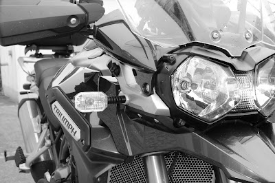
The road south-west was pleasing, lots of twists and turns with the occasional straight thrown in for good measure, although in placed the road surface was worn and rough before we turned south-east at Lough Sarah onto the L1503. We passed through Redhills and onto our accommodation just south of Killybandrick Lough. I had noticed on the journey down that whilst the rear end was gripping really well, the bike felt heavier than usual to thrown into the corners. I had had to pump the tyre earlier and the realisation came that I had a slow puncture. Bugger! The accommodation, however, was an idyll of stillness - there wasn't a sound other than an owl's call in the night as the mist formed after yet another hot day. It helped that Kivi had brought a bottle of Bollinger, in true Bond-esque style. What a revelation! We awoke the next morning to a completely flat tyre on the Explorer; it was interesting, though, that on previous trips and in previous years this might have constituted some sort of drama, a faff and fuss. Perhaps with the patience a few more years under the belt gives you we simply borrowed a compressor from the owners, pumped the tyre up and drove ten minutes north to a tyre centre to get it changed. My God it felt good to be riding the bike again. We made  pit stop at the nearby Clogher Variety Market, itself located just north of Drummully church and graveyard ruins, where we devoured a hefty fry before heading south to Belvedere House and Gardens.

Just south of Finnea and Lough Kinale & Derragh Lough Natural Heritage Area, the R394 cuts through peat bogs in a 6km stretch of arrow straight road that enabled a twist of the throttle and the rising burble from the Explorer's triple engine....glorious! The undulations of the road ensured it was an interesting ride! With hindsight, we should have stopped at the impressive ruins of Abbeylara Cistercian Monastery just 3km west off our southern R394 / N55 route, but we were enjoying our time on the bikes and in what read as 27°C heat, we also needed the air circulating around us! It was at Castlepollard that my mouth felt like, and resembled sandpaper. The heat was stifling and I knew at this stage that I had no-where near enough fluids on board and I was now dehydrating quickly. An important lesson learned, and in future I will ensure I drink plenty - although needing the toilet on a bike is also an issue, it quickly becomes all you can think about! We stopped at Castlepollard for a drink in the midday heat, even meandering at a slow pace was an exhausting task. Castlepollard is a picturesque town with the original layout preserved and centred around a triangular green on which is a water feature and sculpture depicting the local legend of the Children of Lir. The name is from the castle built by Nicholas Pollard, an English Army Captain from Devonshire who fought for Elizabeth I in the Nine Years War. The town's pre-Anglicized name is Baile na gCros (town of the cross). Interestingly nearby is Randún; a Turgesius (Thurgestr / Thorgísl - a Viking Chief in Ireland in the 9th Century) fort / stronghold. Castlepollard is also just 4km west of the great ruins of Fore (which we visited during the 'Vernal Biking Weekend' of 2016).
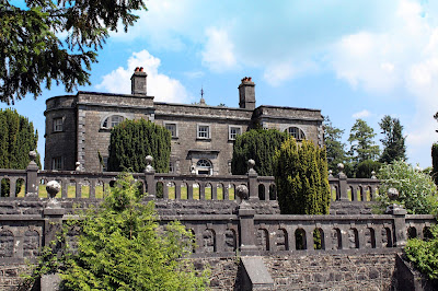
Belvedere House
We continued south, skirting Mullingar, to Belvedere House and Gardens situated on the shore of Lough Ennell. Belvedere was a Georgian hunting lodge built for Robert Rochfort, 1st Earl of Belvedere and is a fine example of Palladian architecture in Ireland. It was built in 1740 by the architect Richard Cassels and when the Earl decided to use it as his main residence he employed the renowned Stuccadore, Barthelemij Cramillion, to create the Rococo ceilings which are widely regarded as some of the best in Ireland. The Earl is perhaps best known as the 'Cruel or Wicked Earl', pertaining to his treatment of his second wife, Mary Molesworth. Around 1743 he believed stories that she had been unfaithful to him with his younger brother and consequently locked her up, alone other than her servants, at the family home of Gaulstown for the rest of his life (thirty-one years). She was only released on the order of her son on his father's death but was, unsurprisingly, extremely damaged by the experience.

Ruins of Rochfort (later Tudenham) House
www.belvedere-house.ie
We took a forest trail up towards the house which also gives superb views upwards to the terracing. But once faced with the building its modest size is what immediately struck me; the building is, at widest, two rooms deep and although grand, is small for such a significant estate. There are only a few rooms on the ground and basement levels open, but the 'tour' is self guided so although not much to see, there is a freedom to it. The rooms are extremely delicate and finely decorated, but again, not sizeable which must have made them intimate in which to socialise, but if its original purpose was as a hunting lodge this is unsurprising. The estate grounds are an exceptionally impressive parkland, dotted with occasional features such as the octagonal gazebo, which would originally have been roofed and served to offer views to the Lough and the estate and the mid-eighteenth Century Gothic Arch which served as mock entrance and focal point for the northern end of the grounds. Perhaps most famous is the Jealous Wall, the largest folly in Ireland which was built c.1760 by the Earl to 'shield' him from the view of another brother, George's, grander residence of Rochfort House (later named Tudenham House) of which he was jealous. It's always easy to judge, and history is written by the eventual victors, but the 1st Earl doesn't exactly sound like a stable individual!

We took time to sit on a bench underneath a tree, buzzing with honey bees, to chat and admire our current situation. It seems a long time ago from those embryonic bike weekends in 2013 and 2014, everything (including the bikes) has changed. We are a well oiled machine now on the road, but I find that the distances between required rest stops is ever decreasing. It was around 4 o'clock that we started the journey northwards, now in need of something to eat as well as drink! But two pints of iced water in Caseys Steak Bar (Ballinagh) still couldn't quell the 'throbbing eye' dehydration headache that soon becomes all-consuming. Once back at the accommodation several pints of water and two Nurofen eased the situation in my head before a Sol and a film to relax. The contented 'humphs' of the horses in the neighbouring field added a suitable soundtrack.

After several morning coffees on Sunday, the journey home commenced in mid afternoon under leaden skies. It was, though, still 'close' and warm. This time the journey would be more or less a straight sling shot north-west to Belfast. Outside Redhills the series of corners were once again a joy as the L1503 becomes the A3 and then N54 before widening to the N2. As ever there is a sense of haste to get home, to compete the journey and, of course, start planning the next!

Friday 12 January 2018

Canarian Winter

Canarian Winter

Tuesday 9 January 2018

Promises of the Winter Sun

The winters here can be somewhat depressing, the darkness feels heavy and can last for what seems like an age each day and, even with the coming of daylight, there is a grimness to the grey wash that seemingly prevails everything. In my experience my mood can mirror this; there are no motorbike breaks and my system is definitely starved of Vitamin D! The Canary Island[s] offered the promise of rest-bite and a much needed break, they also usually guarantee clear blue waters and underwater frolics. 

Nuestra Señora del Carmen (in Plaza de la iglesia)
Los Cristianos differs from its louder, brasher neighbour (Las Americas) as it developed from a small fishing settlement, indeed there are 16th Century references to Los Cristianos by Hernán Guerra as a harbour and it remained an important port in the proceeding centuries. References record that the settlement didn't really develop due to the threat of pirate raids, this sounds like make-believe and like something out of a book, but a true part of the island's past. The first permanent settlement of Los Cristianos was in the 1860's when it was described by Pedro de Olive as "a hamlet in Arona, with three one-storey houses, a two-storey house and a hut." Los Cristianos' natural harbour lent it well to trade and in 1909 the first quay was built to ship the produce of a local distillery; it is still referred to as El Puerto Viejo (the old quay). Arriving in the town, for me, is like seeing an old friend, one that has a metaphorical arm around me. A big part of my psyche, both happy and sad, belongs on the island and for those reasons and experiences it will always resonate in my soul. The chimes from Nuestra Señora del Carmen are now a familiar music that signals reverie and a more leisurely attitude. Immediately noticeable is the cheaper cost of living - a marker for just how hard hit we are with inflation here! But as the sun kisses one's skin la dulce vida (to translate from Italian to Spanish) is here again! 

Dawn through the Guaza 'saddle'
I watched the sunrise - it is probably not for the first time here, but certainly within memory and for the ability to appreciate it it might as well have been - over the Guaza 'saddle'. The cold of the night quickly dissipates when the sun peeps over the crest and within half an hour it is warmer than a summer day at home. One of the new experiences I have had on this break is an early morning walk, and one that is joyous; every morning we passed an elderly lady on the beach, always in the same location, in the midst of her morning Yoga routine. This lady must have been in her 70's but looked one - two decades younger. After this (and on our return route) we would see her coming out of the sea from her post-Yoga swim....what a way to start the day! I have to remind myself that I am on holiday and the Utopian dream I have in my head of a 'simpler life' also needs work to make it a success. No longer, though, can this (or any activity) be put off 'until tomorrow' or 'we'll do that soon' for it will either never come or come so soon it passes us by. Life is perilously short. With that in mind I was relieved when I was able to book some dives with Sa Caleta.  Even after booking I was palpably relaxed and was like an excited boy waiting to get on the boat and get submerged. I learned, with dismay, that the turtles from El Puertito (a site I had dived and written about here) had to be moved due to people interfering as humans always seem to default to, trying to grab their fins etc. Why we can't just leave well alone I'll never know. However, they have a new habitat off the Tenerife coast and our first dive would be with them and sting rays.
An Atlantic green turtle off the southern Tenerife coast
Turtles are an enigmatic creature, to me they have a somewhat forlorn facial appearance but very expressive eyes. Up close they look at you with a piercing quality. The green sea turtle (Chelonia mydas) is distinct as it has a large teardrop-shaped carapace (shell) and large flippers that have been used to slap me in the past to gain my attention. Those that reach maturity can live to be 80 years old in the wild. Seeing them again and being so close to them was, as ever, an uplifting experience mentally, emotionally and spiritually which signalled how the rest of the dive would proceed. Despite my dive computer battery going flat, the dive was serene, a school of Barracuda hovered overhead and curious wrasse were keen to see what was going on. Then, from the 'desert' of the sandy bottom, a sting ray 'flew' into view. It glided underneath me before turning to presumably to resume the never ending hunt for food. We hugged the volcanic rocky shelf, swimming through shoals of fish before making the ascent to the boat. 

The wreck of El Condesito
There was another dive the next day, to an old favourite; the site of El Condesito near Las Galletes. El Condesito is a cargo ship that sank on 1st January 1972 near Las Galletas on the south coast of Tenerife. The wreck is now a well-known recreational dive site. The ship was transporting cement for the construction of Los Cristianos. The ship ran aground about 50 meters (165 feet) from where the Punta Rasca Lighthouse later was constructed (no lives were lost). It was this sinking that prompted the construction of the lighthouse three years later; there are differing stories as to what happened, with some stating the ship suffered engine trouble during a storm and others that the captain and crew were drunk. Until recently the hull, engine room and cabin were intact with only the bow having been torn away. However, the wreck is increasingly unstable but can still be penetrated from many entry points. Access is easy from the forward hold swimming through the remains of the cargo. The bags of cement she was carrying have now solidified into blocks, and all around the site are white solid "stones" that are actually the now-solidified bags of cement. There is a 36 m (118 ft) drop-off nearby which is often dived by more experienced divers to see the famous Black Coral (which I have dived) before ascending to "off-gas".  As ever, the size of the Trumpet Fish in the ship interior was phenomenal, the wreck acts as something of an artificial reef for a variety of species. It is nestled in a series of 'horseshoe' volcanic rock formations that are explored as part of the dive at the site. There was, though, relatively little to see after the wreck proper. I knew that this would be my last dive here for this visit and as the time was quickly drawing to a close there is a realisation that normality will soon resume.

This trip represented a much needed break for Nicola and I and our first time away for nearly three years! Doesn't time go by with increasing speed?! Whether here or other locations there is little doubt that we will not leave it so long next time. Thanks to all for their hospitality.