Showing posts with label Triumph. Show all posts

Tuesday, 15 September 2020

Down & Louth in Late Summer Heat and C-19

It has been quite some time since I have posted anything on this blog, mainly because it has been quite some time since I have been anywhere! - a situation compounded by the world-wide pandemic of C-19. A new reality faces us all and this is especially pertinent to far-flung travel; will it ever be the same again? My own opinion is that travel has been irreversibly affected, which means seeing what's on our own doorstep hones into closer view; the term 'staycation' is bandied about, but that's what we've been doing for years on the bikes - we must have been ahead of the curve! It is, though, slightly wistfully that I write this piece, I can't help but wonder the frequency with which I/we will get to go anywhere, every passing week it seems there are new restrictions in place (something I am not opposed to), but combined with time marching on in terms of my own life I find myself looking back at 2014, 2015 and the amount of time we spent on the bikes and think that that must now represent the zenith of our biking adventures. 

This trip represented the first time I had had my leg over the bike since France last year (for the 75th anniversary of D-Day). The weather was set fair, and it there were just two of us on this particular weekend; albeit we wouldn't be travelling huge distances, rather 'day trips' on the bikes. We chose South (County) Down as the location, mainly because the coastal roads and the scenery is nothing short of spectacular, throw in some summer weather and it is genuinely hard to beat. The roads can become clogged with people going to Newcastle, Murlough or the Mournes, but now more than ever I am content to amble behind for a bit, rather than immediately reaching to twist the throttle and overtake. A point that I seem to have visited a lot on bike trips is St. John's Point lighthouse (near Killough). But I had always wanted to see the little early Medieval church that one passes en route to the lighthouse. In truth, though, it is archaeologically important as an early stone church, but other than that a tad uninspiring. The road to it is tight and at times the hedgerows completely enclose you, and after nearly being hit by a large Range Rover on a preceding bend, stopping at the site is difficult. 

St. John's Church
There are three walls remaining (although Harris writing in the mid-18th Century described it as intact), it is a pre-romanesque church, almost certainly on site of earlier wooden church, with sloping jambs and antae (were originally used to support wooden roofs on large churches, but this structure had a stone roof - the use of these is what furthers the suggestion that it replaced an earlier wooden church; Adomnán, 2012). Whilst maybe not architecturally spectacular, it is nevertheless enigmatic. It is associated with Eoan (John), son of Cairlánd. In 1977 an excavation was carried out that recovered early Christian burials - many children and adolescents - approximately 23 in total. The style of the building is what is used to date it and it is unlikely to be earlier that 8th Century and unlikely to be later than 10th Century (ASCD, 1966, 295-296), so built between c.700AD - 900AD. We were, though, slightly hot in the heat of the day and drove past the church towards the southern tip of the peninsular and the lighthouse. The lighthouse is intriguing; like a host of man-made infrastructure was air-lifted onto this natural setting. The lighthouse still contains its mercury light (upgrading to modern tech is being fought by those around the site). Much of the ancillaries also remain with what looks like a giant fog-horn type mechanism, with lots of rusted metal and engines lying around it. There is a cottage (still lived in, so if visiting please be respectful that this is still someone's home), complete with a goat wandering on top of the walls that at one point seemed to be staring us out! 

The Road Leads South
We hugged the coast road south towards Newry (the last time I was here on a bike, it was also exceptionally warm), I don't know what mindset I was in, but I was exceptionally chilled and happy to simply 'be' on the bike - maybe a product of not having been on the bike in a while or maybe I was just glad to be out and about during the pandemic. Just south of Newry, the R173 / R176 road hugs the Carlingford Lough coastline, perched high above it to give fantastic views over the water and the rising mountains to each side. The mountain at Glenmore rises to the right hand side and there is a feeling of being cocooned between the water and it, but not in an oppressive way, it is strangely comforting. The traffic began to intensify as everyone had had the same idea as us, albeit not on bikes. I was glad I had worn my RST leather jacket, rather than the heavier (and warmer Dainese textiles).  As we approached Carlingford (a location we always seem to either pass through or stop at) the sheer number of people became apparent. Cars were parked everywhere and every little bit of kerb and potential space had been taken - the advantage of a bike is that it can be 'hoofed' up onto the pavement without taking much room. There is also always a head-turning moment as people seem to want to see the bikes - usually this is more the case with the classic BMW's as they are evocative and much more what people think of as a bike rather than the more angular (and frankly less attractive) Triumph Explorer; but there were still some people going up close to 'the wraith'. 

Carlingford in all its Glory
You don't even have to be a big fan of medieval buildings or architecture to enjoy Carlingford, it is exceptionally quaint and (as it still largely follows the medieval town footprint) is easy to navigate. However, I have always marvelled at the plethora of medieval buildings that still remain - a credit to those that may have rejected planning permissions for any modernity. 

We soon found that we just wanted to sit and watch the world go by - initially on the harbour wall and then on a little patch of grass that looked onto the beach, the bay and the impressive St. John's Castle. The castle is late 12th century building (initially the great D-shaped enclosure castle with the east wing added in c.1261). It was likely built by Hugh de Lacey but acquired its name due to the belief that King John stayed there for several days in 1210 when he came to Ireland to apprehend de Lacey (1st Earl of Ulster). I've never been into the castle, so it remains firmly on the 'to do' list as I think it would be akin to visiting Trim Castle (well worth the visit - followed by something in Ruby Ellen's Tea Rooms if people are ever allowed back into such places!). It was on this 'grassy knoll' that existential conversations took place, always something that is to be relished on trips away. I had recently read Schröeder's theories that as we all essentially came from the Big Bang, we are therefore all connected - physically, biologically and, therefore, consciously. If you're interested read: 'We are all Aspects of One Single Being: An Introduction to Erwin Schröeder', 1984, pp809-835. Social Research, Vol 1, No. 3. We must have sat (and maybe dozed) for an hour or so before we decided to head northwards - or rather due east - to Greencastle (not to be confused with the splendid castle in Donegal of the same name, in fact there seem to be a few Greencastle[s] in Ireland). The road north differed from our journey south in that we, this time, took the road the hugs the east side of Carlingford Lough - the A2. 

A Mighty Norman Castle
Greencastle is another site I have always wanted to visit - alas currently closed due to C-19. But nevertheless well worth visiting just to see what remains. It is well signposted and surrounded by other monuments (e.g., raths) that pepper the Irish landscape. Greencastle (Co. Down) occupies a [high] tip of land protruding into Carlingford Lough and its strategic and defensive position is easy to see. 

It is likely to have been built by Hugh de Lacy, along with Carlingford Castle on the opposite side of Carlingford Lough, to guard the narrow entry channel to the Lough, and the ferry crossing between the two. The motte from the earlier Norman, wooden, Motte and Bailey Castle (possibly built by John de Courcey) is still on the seaward side nearer the point. According to one legend John de Courcy was married at Greencastle Castle, but this may have been at the original motte & bailey castle. According to the information boards at the site it was held for the English Crown by Richard de Burgh, Earl of Ulster, from 1264–1333. It was attacked and taken by Edward Bruce in 1316, attacked at least twice by native Irish in the later 14th century but still maintained as a garrison for Elizabeth in the 1590s. It is approached across a rock-cut ditch. Although the castle dates mainly from the 13th century, there are  substantial 15th and 16th century alterations. The skies were clear and a deep blue and this (along with the whole trip) had done wonders for my soul, slightly fatigued and jaded from the whole lockdown experience. 

I can't help but wonder when we will next get some time on the bikes (I have come to accept that long weekends away will likely be few and far between), but even for a day out. It is now September (usually a great month to go away on bikes as the weather is usually better than June/July!). But darker nights and colder, wetter weather is on its way in, so the next time will likely be 2021....I wonder what state the world will be in then?

Friday, 15 June 2018

The Tropical Midlands

An Irish summer, it seems to me, can be hotter than traditional holidays to 'suntraps' abroad. I don't know why but the sun seems stronger somehow, more ferocious and I have a tendency to more readily burn in its intensity. The last few weeks have been thus and we were due to take a biking weekend away - the first in a year - at the tail end of this tropical bake. Cavan is an under-visited county, seemingly the poor neighbour to the likes of Meath and Sligo, but this also has the advantage of lowering prices for accommodation. When I researched what there was to see and do there were a surprising amount of little sites in close proximity such as Drumlane, Aughrim wedge tomb and even Abbeylara, but for larger attractions (Louchcrew, Parke's Castle, Strokestown et al) there is a bit of a drive involved. That was fine though, as with so little saddle time between us over the last 12 months, a drive was what was desired.
With it fast approaching the Summer Solstice the nights are short, with streaks of pale daylight still visible around midnight; it seems hard to believe that in little over a week's time the days will start getting shorter! The times seems easy with so much light, it adds an 'airiness' to one's psyche. Little wonder, then, that in ancient times it was the Winter Solstice that seemed to be more revered - a plea for the short days and long nights to cease. For a biking trip the summer adds flexibility and a more sedate pace as even if late, there'll be plenty of light and therefore time to arrive somewhere and settle in. The Friday night drive down, for me, was in leathers and jeans although I feared at one point as large thundery drops started bouncing off my helmet that I would regret that decision, but the rain didn't amount to much. In clear humid air, we initially travelled west from Keady towards Clontibret (famous for the Battle of Clontibret), to Castleshane and then Monaghan town before turning south west through Clones. Clones (from the Irish Cluain Eois - Eos's Meadow) is a historic town which originated as a monastic settlement founded by Tigernach [mac Coirpri] in the 6th Century within the 'kingdom' of Dartraige Con-innisi. The Dartraige were an Irish túath (a túath was a Medieval Irish polity smaller than a Kingdom, the word is from the old Irish which can be translated as 'people' or 'nation' and is cognate with the Welsh and Breton tud also meaning 'people'). Dartraige Con-innisi translates as Dartraige (Dartry) of the Island Chief. The ruins of a 12th Century abbey and a round tower can still be seen in the town alongside a stone shrine to St. Tigernach.

Bollinger Friday
The road south-west was pleasing, lots of twists and turns with the occasional straight thrown in for good measure, although in placed the road surface was worn and rough before we turned south-east at Lough Sarah onto the L1503. We passed through Redhills and onto our accommodation just south of Killybandrick Lough. I had noticed on the journey down that whilst the rear end was gripping really well, the bike felt heavier than usual to thrown into the corners. I had had to pump the tyre earlier and the realisation came that I had a slow puncture. Bugger! The accommodation, however, was an idyll of stillness - there wasn't a sound other than an owl's call in the night as the mist formed after yet another hot day. It helped that Kivi had brought a bottle of Bollinger, in true Bond-esque style. What a revelation! We awoke the next morning to a completely flat tyre on the Explorer; it was interesting, though, that on previous trips and in previous years this might have constituted some sort of drama, a faff and fuss. Perhaps with the patience a few more years under the belt gives you we simply borrowed a compressor from the owners, pumped the tyre up and drove ten minutes north to a tyre centre to get it changed. My God it felt good to be riding the bike again. We made  pit stop at the nearby Clogher Variety Market, itself located just north of Drummully church and graveyard ruins, where we devoured a hefty fry before heading south to Belvedere House and Gardens.
Just south of Finnea and Lough Kinale & Derragh Lough Natural Heritage Area, the R394 cuts through peat bogs in a 6km stretch of arrow straight road that enabled a twist of the throttle and the rising burble from the Explorer's triple engine....glorious! The undulations of the road ensured it was an interesting ride! With hindsight, we should have stopped at the impressive ruins of Abbeylara Cistercian Monastery just 3km west off our southern R394 / N55 route, but we were enjoying our time on the bikes and in what read as 27°C heat, we also needed the air circulating around us! It was at Castlepollard that my mouth felt like, and resembled sandpaper. The heat was stifling and I knew at this stage that I had no-where near enough fluids on board and I was now dehydrating quickly. An important lesson learned, and in future I will ensure I drink plenty - although needing the toilet on a bike is also an issue, it quickly becomes all you can think about! We stopped at Castlepollard for a drink in the midday heat, even meandering at a slow pace was an exhausting task. Castlepollard is a picturesque town with the original layout preserved and centred around a triangular green on which is a water feature and sculpture depicting the local legend of the Children of Lir. The name is from the castle built by Nicholas Pollard, an English Army Captain from Devonshire who fought for Elizabeth I in the Nine Years War. The town's pre-Anglicized name is Baile na gCros (town of the cross). Interestingly nearby is Randún; a Turgesius (Thurgestr / Thorgísl - a Viking Chief in Ireland in the 9th Century) fort / stronghold. Castlepollard is also just 4km west of the great ruins of Fore (which we visited during the 'Vernal Biking Weekend' of 2016).

Belvedere House
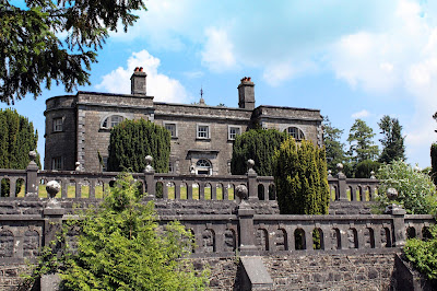
We continued south, skirting Mullingar, to Belvedere House and Gardens situated on the shore of Lough Ennell. Belvedere was a Georgian hunting lodge built for Robert Rochfort, 1st Earl of Belvedere and is a fine example of Palladian architecture in Ireland. It was built in 1740 by the architect Richard Cassels and when the Earl decided to use it as his main residence he employed the renowned Stuccadore, Barthelemij Cramillion, to create the Rococo ceilings which are widely regarded as some of the best in Ireland. The Earl is perhaps best known as the 'Cruel or Wicked Earl', pertaining to his treatment of his second wife, Mary Molesworth. Around 1743 he believed stories that she had been unfaithful to him with his younger brother and consequently locked her up, alone other than her servants, at the family home of Gaulstown for the rest of his life (thirty-one years). She was only released on the order of her son on his father's death but was, unsurprisingly, extremely damaged by the experience.

Ruins of Rochfort (later Tudenham) House
www.belvedere-house.ie
We took a forest trail up towards the house which also gives superb views upwards to the terracing. But once faced with the building its modest size is what immediately struck me; the building is, at widest, two rooms deep and although grand, is small for such a significant estate. There are only a few rooms on the ground and basement levels open, but the 'tour' is self guided so although not much to see, there is a freedom to it. The rooms are extremely delicate and finely decorated, but again, not sizeable which must have made them intimate in which to socialise, but if its original purpose was as a hunting lodge this is unsurprising. The estate grounds are an exceptionally impressive parkland, dotted with occasional features such as the octagonal gazebo, which would originally have been roofed and served to offer views to the Lough and the estate and the mid-eighteenth Century Gothic Arch which served as mock entrance and focal point for the northern end of the grounds. Perhaps most famous is the Jealous Wall, the largest folly in Ireland which was built c.1760 by the Earl to 'shield' him from the view of another brother, George's, grander residence of Rochfort House (later named Tudenham House) of which he was jealous. It's always easy to judge, and history is written by the eventual victors, but the 1st Earl doesn't exactly sound like a stable individual!

We took time to sit on a bench underneath a tree, buzzing with honey bees, to chat and admire our current situation. It seems a long time ago from those embryonic bike weekends in 2013 and 2014, everything (including the bikes) has changed. We are a well oiled machine now on the road, but I find that the distances between required rest stops is ever decreasing. It was around 4 o'clock that we started the journey northwards, now in need of something to eat as well as drink! But two pints of iced water in Caseys Steak Bar (Ballinagh) still couldn't quell the 'throbbing eye' dehydration headache that soon becomes all-consuming. Once back at the accommodation several pints of water and two Nurofen eased the situation in my head before a Sol and a film to relax. The contented 'humphs' of the horses in the neighbouring field added a suitable soundtrack.

After several morning coffees on Sunday, the journey home commenced in mid afternoon under leaden skies. It was, though, still 'close' and warm. This time the journey would be more or less a straight sling shot north-west to Belfast. Outside Redhills the series of corners were once again a joy as the L1503 becomes the A3 and then N54 before widening to the N2. As ever there is a sense of haste to get home, to compete the journey and, of course, start planning the next!